
|
|
|
Trail Plans The Friends of Amelia Island Trails plan showing existing, planned and conceptual trails. Trails on Amelia Island
Narrative: This "glamour shot" illustrates the overall view of Amelia Island from about 10,000'. It's not your typical trails map. But, it may give you a feel for the scale, reach and impact of our local organization, Friends of the Amelia Island Trail, and its success over the years. Each of the trails, paths and sidewalks depicted had their origin in the belief that quality of life for residents and our visitors could be improved by constructing additional safe riding, running and walking opportunities.
This updated image shows mostly future projects. The yellow line on the map is our major, current project, the Schools to Downtown Waterfront Trail. It would start near FB High School on Citrona Dr. and run westward ending at the City's waterfront. With the anticipated re-start of the Fernandina-St Marys Ferry Service, the SDWT would become a link in the National East Coast Greenway. The light pink line depicts a conceptual Atlantic Av to North End Boat Ramp Trail of 2.3 miles which would basically follow N 14th St. The light green lines depict existing sidewalks around Southside Elementary School which were constructed with funds from a grant from the National Safe Routes to Schools Program. The bold red line depicts the future marking of the existing road shoulder on S 14th St as a bicycle lane; this is expected in the Spring of 2020. The short red line under the walkers silhouette depicts two sidewalk segments proposed as a project for COFB to enhance pedestrian and cyclist safety in this area. The orange line from Atlantic AV southward alongside Citrona Dr. and Will Hardee Rd. to Simmons Rd is a concept to improve sidewalks and/or add a bike trail. Not depicted are the marked bicycle lanes on S Fletcher Av/A1A from Atlantic Av to the south end of Amelia Island which were added several years ago based on FOAIT recommendations and lobbying efforts made to Florida Department of Transportation authorities. By formally requesting addition of bicycle lanes before the resurfacing project was completely planned, this significant 11 mile bicycle lane addition was incorporated into the State's construction contract
Narrative: The attached map shows most existing and proposed trails and paths between Sadler Rd and the roundabout at S. Fletcher and Buccaneer Trail. A. Our recently-completed Amelia River-to-Sea Trail (in red) runs east-west from the new public park on Crane Island to beach access #30. The eastern 2.4 mile segment is paved, while the western 4/10 mile loop is natural surface and provides access to the new public pier which extends into the Amelia River. Trailside amenities are being planned and funded by Friends of the Amelia Island Trail. Nassau County is presently installing a 4-way stop at the intersection of Simmons Rd. and S. 14th St. where the trail crosses S. 14th St. This trail project itself was funded by a federal grant through the First Coast Transportation Planning Organization (FCTPO) and with very significant support from the Crane Island Development and Nassau County. B. The green 1.5 mile segment on the map between Sadler Rd and the Amelia Island Parkway (AIP) is a paved sidewalk along the east side of S 14th St., constructed about 7 years ago with funds from an FDOT grant. Marked with green lines, just to the east of S. 14th St, two sidewalks were constructed using a Safe Routes to Schools grant around Emma Love Hardee Elementary School. Sadler Road, a primary west-east arterial road, has sidewalks and marked bike lanes for its entire length. Automobile traffic is extremely heavy on the western half of Sadler Rd. C. The orange north-south line along Will Hardee Rd. depicts envisioned construction of an off-road path. There is currently a sidewalk along this route and traffic is generally light. D. Four new segments of a 3.25 mile extension of the Amelia Island Trail have been approved by the NFTPO for future construction. These trail segments will run generally northwest-southeast and parallel the Amelia Island Parkway (AIP) from the intersection of A1A and AIP near "Gateway to Amelia" to S. Fletcher Avenue/A1A. Design of "Segment 1" from S. Fletcher Av. to Via Del Rey will happen in 2023. The entire length of Amelia Island Parkway has marked bicycle lanes and, despite carrying increasing volumes of motor vehicle traffic, is a popular route for local cyclists. E. The heavy red segment on the map marks a portion of county-maintained Buccaneer Trail; it has wide shoulders along the first 7/10 mile which we propose converting to marked bicycle lanes. This route is frequently used by North Florida Bicycle Club cyclists. The segment of Buccaneer Tr. south of Canopy Road is narrow with moderate traffic volume but no shoulder or bike lane and is not recommended to bicycle travel; there is a narrow 4' sidewalk along the west side of the road from Amelia Island Parkway to the roundabout at S. Fletcher Av that can be safely used by cyclists. F. The green segment marked on city-owned Shannon Road leading to a golf course just west of Buccaneer Trail is the site of a proposed roadway marking project using "Sharrows" (shared road markings) which are used on narrow roads reminding motorists to safely share the roadway with bicyclists. G. South Fletcher Av./A1A, marked in yellow, runs north to south along the Atlantic Coast here and has marked bicycle lanes for its entire length. It is often used by local and visiting cyclists. Caution: many service vehicles park in these bike lanes and blowing sand can cover sections of the northbound bike lane.
Narrative: This attached map shows the trails and paths in this south-central section of Amelia Island. A. The Amelia Island Trail (in red) begins at its northern trailhead at Peters Point Beachfront Park and initially heads southwest then south alongside S. Fletcher Av/A1A to Burney Road. The AIT trailhead is located within Peters Point Park and has an information kiosk with a map of the entire East Coast Greenway, maps of other local existing and proposed trails, and Nassau County trail rules. After departing the Park, this paved off-road Trail heads southwest, crosses A1A at the S. Fletcher/Buccaneer Trail roundabout, then again crosses A1A just south of Quattlefield Rd. This 6.6 mile trail was funded by a federal grant obtained through the North Florida Transportation Planning Office (NFTPO) and completed in 2013; it is maintained primarily by Nassau County with significant support by the Amelia Island Plantation and trail volunteers. (Description of the southerly portion of the AIT is in the next narrative section.) B. Generally following the Amelia Island Parkway (yellow line) a narrow paved sidewalk winds alongside the road from its intersection with S. Fletcher Av southward for 1.7 miles to its intersection with A1A. This sidewalk, often called the "Summer Beach Trail" serves as a safe "by-path" for local walkers and cyclists. C. Two short trails are depicted in green. The first is a planned trail starting on A1A which will use a recently-closed portion of Orange Av then connect with an existing abandoned roadway to reach Amelia Island Parkway. This project is a collaboration between local community associations and Nassau County. It is not yet named. The second green line nearby on the map depicts a trail which was just paved in October and will soon be open for use. It will provide residents in The Enclave with access to the Amelia Island Parkway. Primary use is expected to be by local residents to walk between their homes/condos and the existing public beach access just to the north along the Parkway. It will be open to the general public (for non motorized use). The purple line marks the Nassau County public beach access trail. D. Starting at the intersection of A1A and Julia St (coincident with AIP) an asphalt sidewalk heads east then branches slightly right to follow Julia St to the American Beach Museum and Community Center. At one time Nassau County planned to continue this trail eastward to Ocean Av then south along Ocean Av then west along Burney Rd back to A1A; however, there has been no follow-up funding identified to complete this concept.
Narrative: B. The Amelia Island Trail bisects the Amelia Island Plantation. There are numerous trails and paths within the boundaries of the AIP; however those routes are only available to owners and guests.
This image shows the Old Town Trail, a future project. This trail is planned to run aproximately 2.3 miles from Atlantic Avenue along N 14th Street, past Bosque Bello cemetery and Old Town to Egans Creek, and eventually to the North End Boat Ramp. It is a park-to-park trail connecting the City’s Central Park with the County’s Dee Dee Bartels Park, and potentially to the State’s Fort Clinch State Park. Currently North 14th Street is a dangerous road for cyclists and walkers, particularly between Broome St. and Egans Creek. The road is a narrow highway with no sidewalk or paved shoulders. It is hilly and provides little opportunity to see oncoming traffic. Of particular concern are the large boats on wide trailers being towed to and from the North End Boat Ramp. The trail will provide a safe route for cyclists and walkers.
The Friends of the Amelia Island Trails, on February 18, 2020, asked the city of Fernandina Beach to approve three projects to add sidewalks and trails. The projects are:
Trails in Nassau County not on Amelia Island
Narrative: This image depicts a notional route for a proposed trail linking Chester Road with US 17. Several years ago, Rayonier, Inc. donated the right-of-way for a new road that would connect Chester Rd with US17. This was done in anticipation of Rayonier building out their residential plan for this area. In discussions with Nassau County in that same time-frame, we proposed that a full-length off-road paved trail also be completed when this new road is constructed. There is no detailed plan, construction start date or promise for this road or the trail, but Friends of the Amelia Island Trail considers this a "place holder" to Nassau County so that when a decision to construct the new road is made, then this proposed parallel 7-mile off-road trail could be seriously considered as a part of that project. Once constructed, this proposed route would likely become a portion of a North-South bicycle corridor (perhaps the East Coast Greenway).
Image 2: (Proposed FPU Power line Trail) Narrative: This image depicts a proposed multi-use trail that would follow the existing FPU power line ROW from A1A near Pine Grove Place (near the sweeping curve of A1A) going south and then westward for approximately 3.5 miles crossing Old Nassauville Rd and Amelia Concourse before terminating at or near Bostick Woods Drive in North Hampton. This trail would serve a large and growing young population moving into this area and would be very deserving of priority support by Nassau County and the FCTPO. It would also serve as an alternative and safer east-west bicycle corridor than A1A, potentially becoming part of the East Coast Greenway. This trail is in the conceptual stage, proposed by the FOAIT to the NC planners.
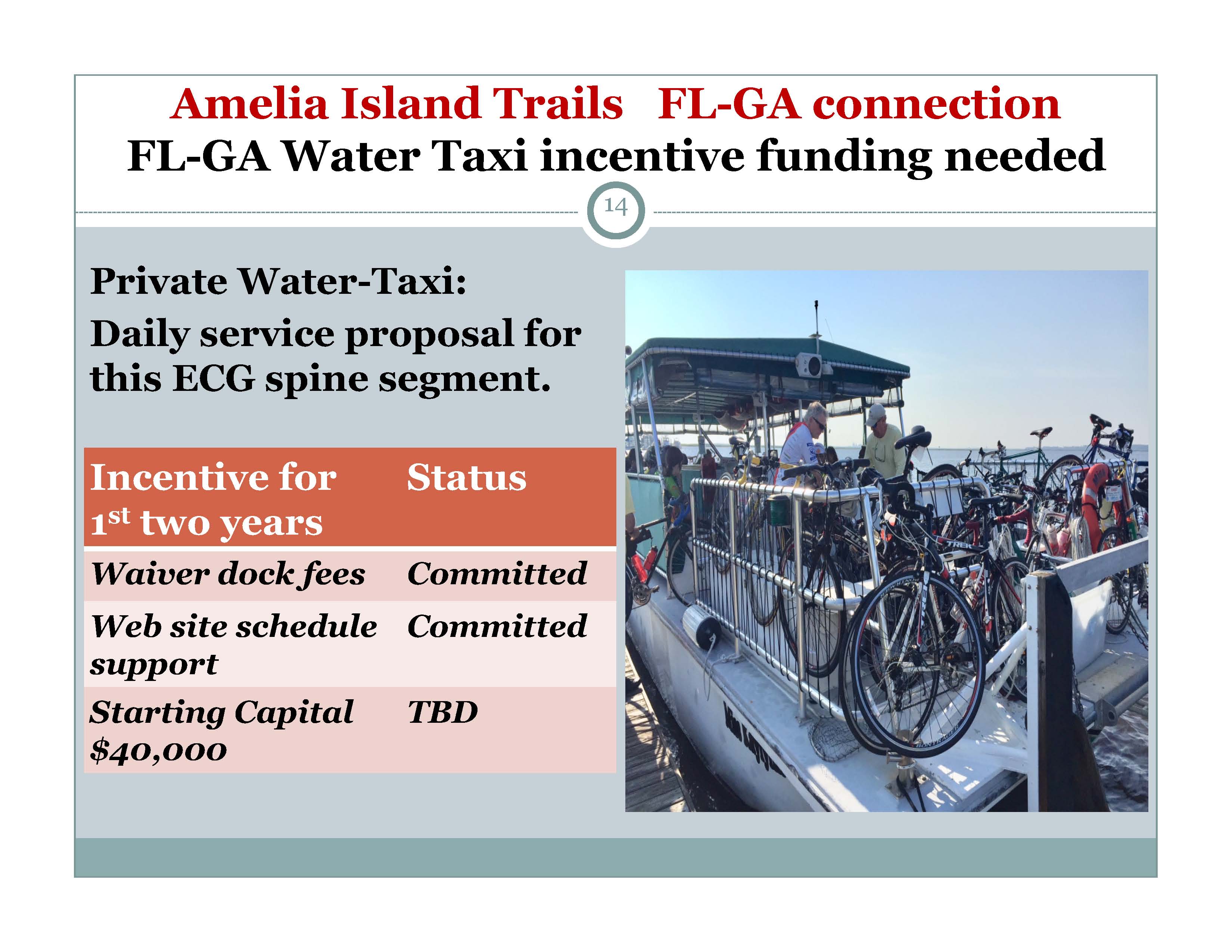
The Friends of the Amelia Island Trails has been working with the city of Fernandina Beach to restablish a water taxi that runs between Fernandina Beach and St Marys, Georgia. On 11/5/19, the city of Fernandina Beach approved Amelia River Excursions to provide the taxi service, with an expected start date of spring 2020 based on restablished fuel service at the marina. Fernandian Beach and St Marys have each approved a $10,000 grant for the service and free dockage for the first two years. The expected start date has been moved back, and now depends on the status the Covid-19 pandemic, Fernandina Beach marina repairs and fuel service, and decisions of the Fernandina Beach and St Marys local governmant. Service may start as early as spring of 2021. Both cities have agreed to carry the funding forward.
Trails in Duval County (Jacksonville) near Amelia Island
|
|
Home | Maps | About Us | Contact Us | Copyright © 2001-2013 Friends of Amelia Island Trail |
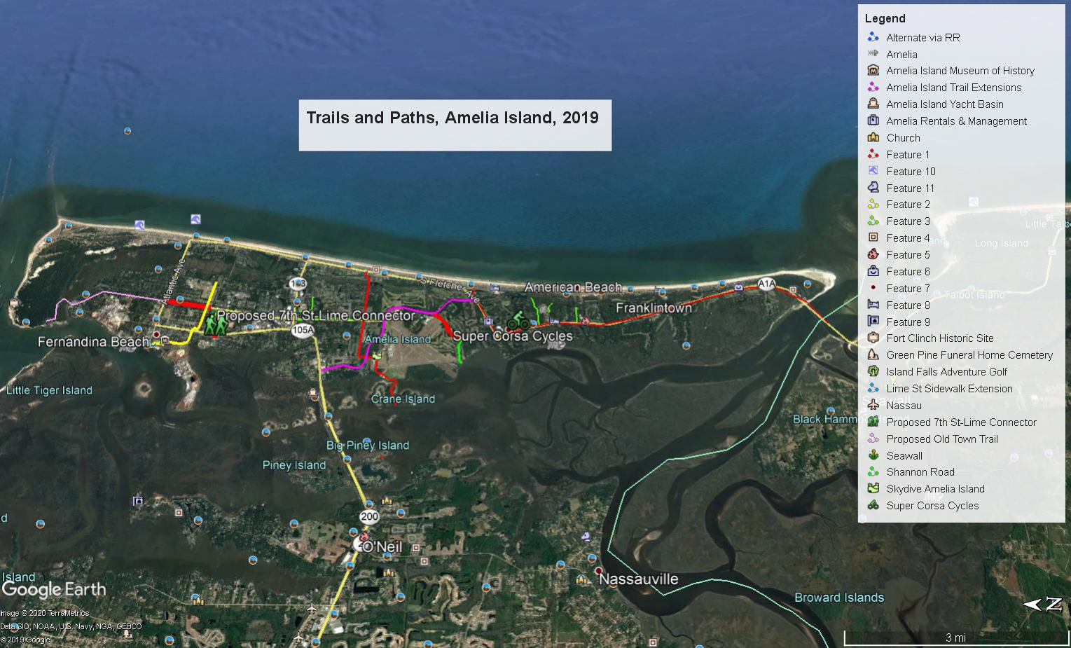 Image 1: (Amelia Island Trails Full View)
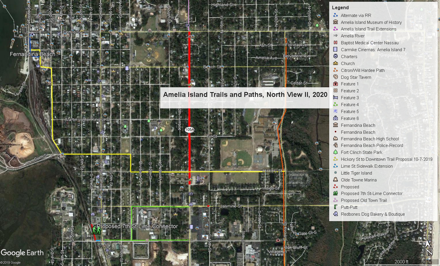 Image 2: (Amelia Island Trails and Paths North View)
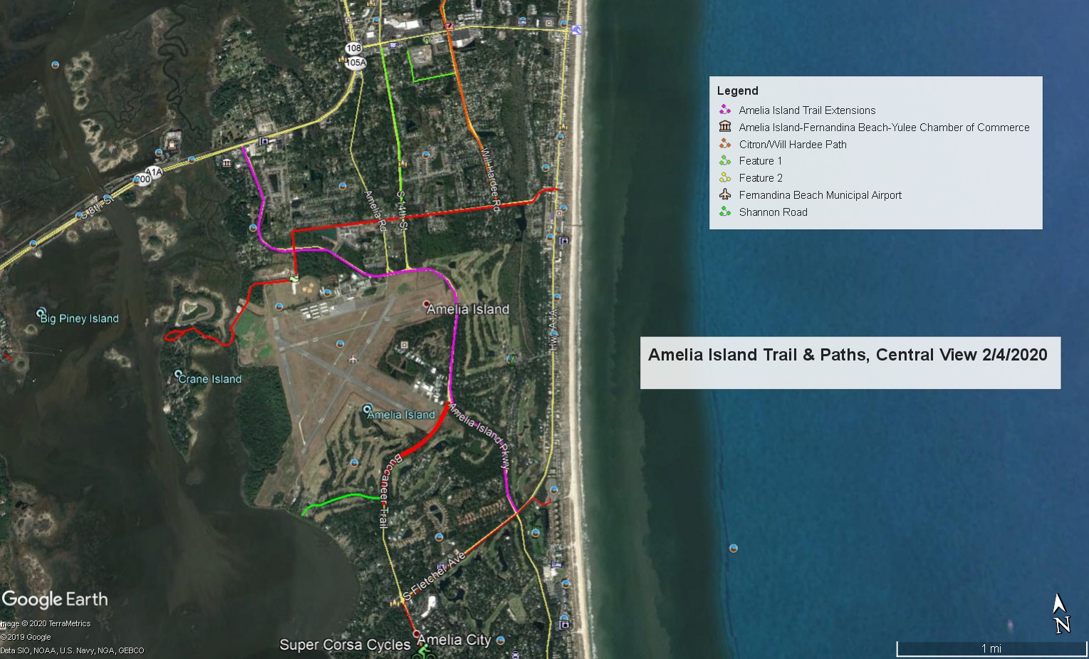 Image 3: (Amelia Island Trails and Paths, Central View 2020)
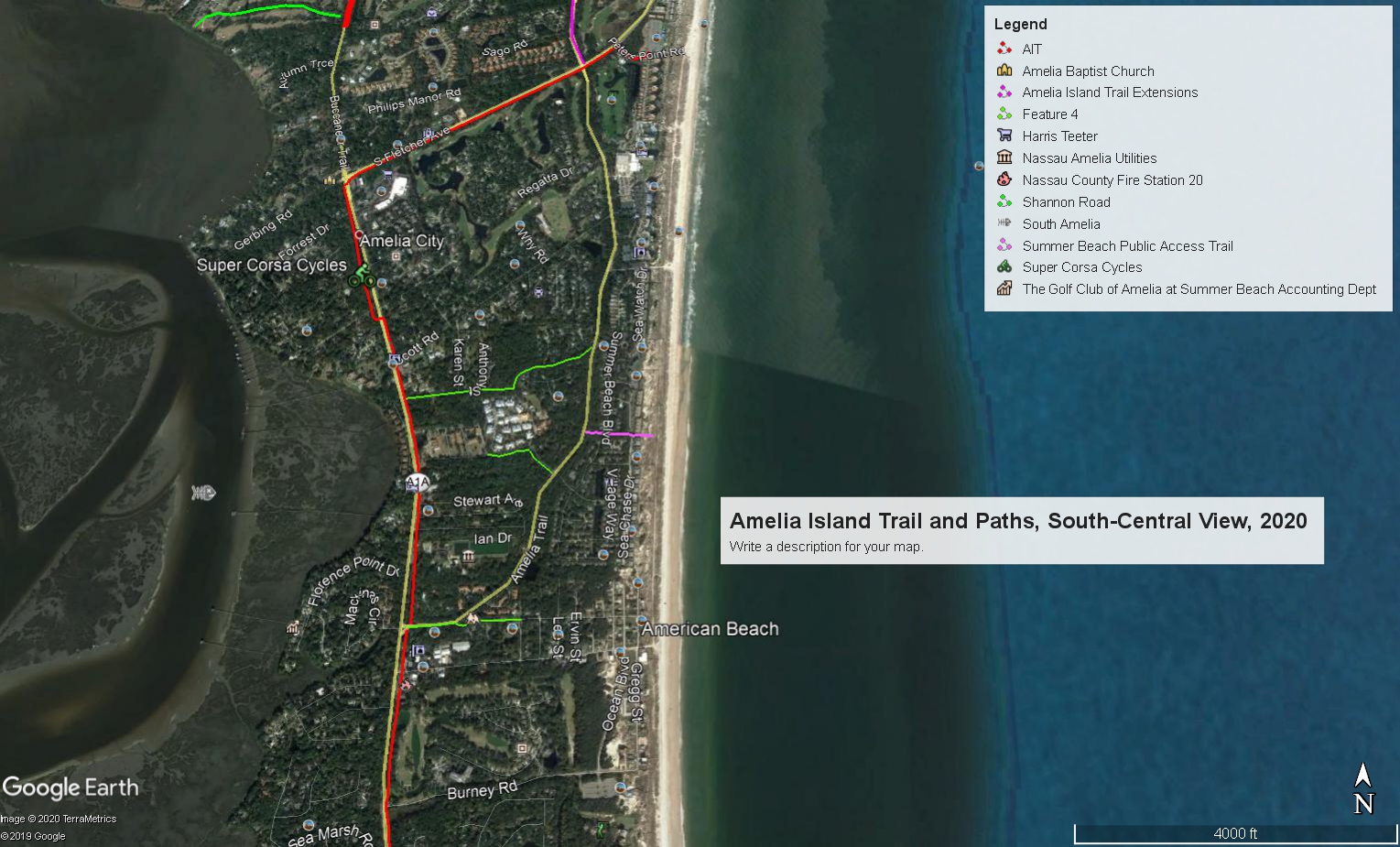 Image 4: (Amelia Island Trail and Paths, South-Central View, 2/8/2020)
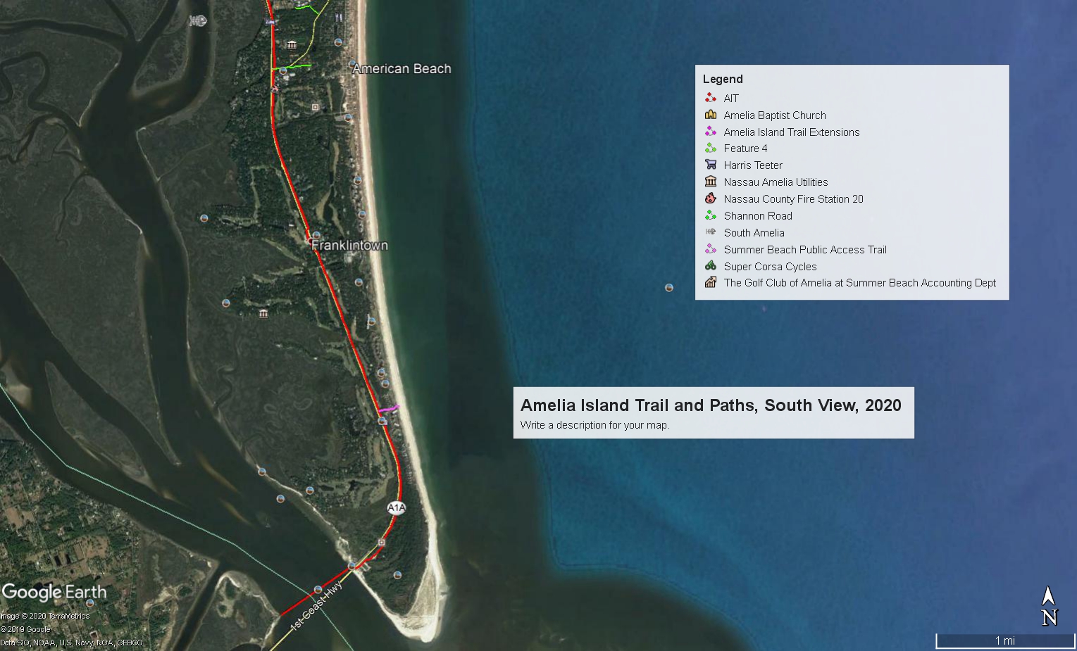 Image 5: (Amelia Island Trails and Paths, South View, 2/8/2020)
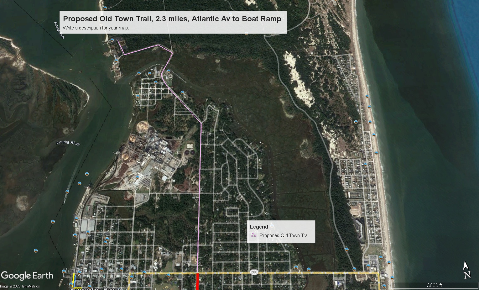 Image 6: (Amelia Island Trails and Paths Very North View)
 Request for 3 new trail/sidewalk projects (2/18/20)
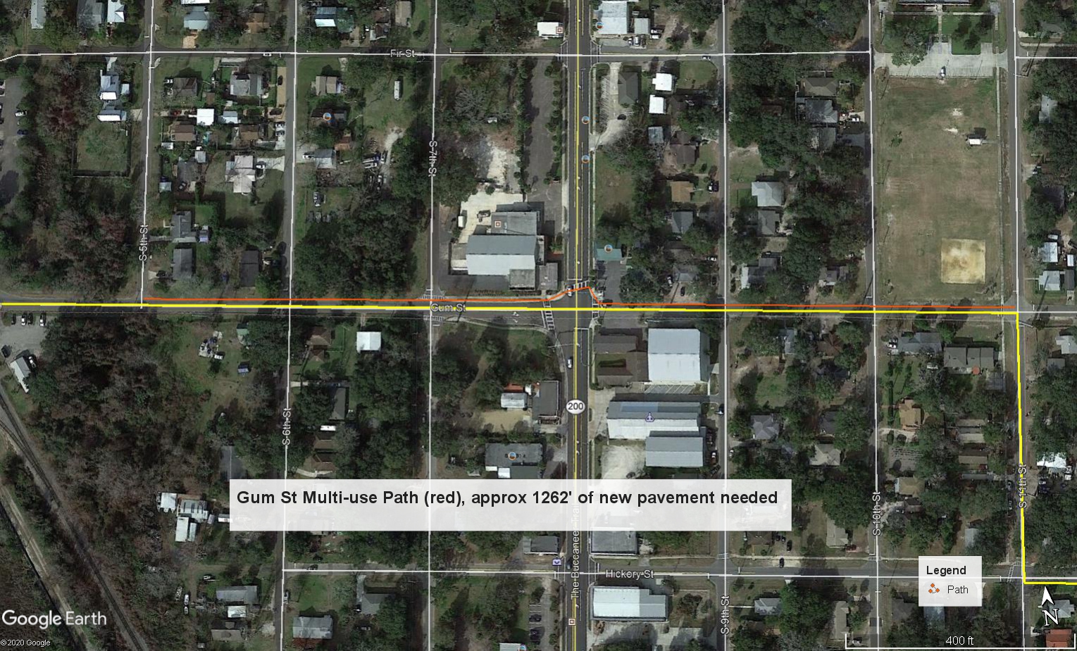 Proposed Gum Street Trail
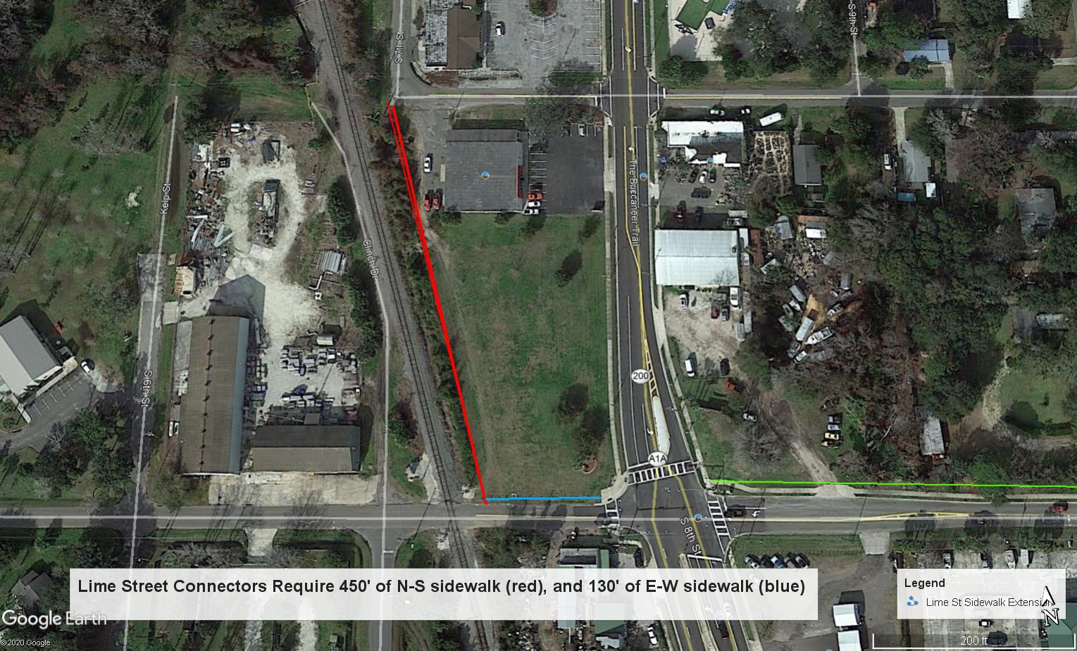 Proposed Lime Street Connector
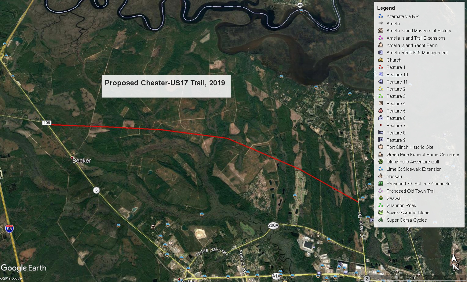 Image 1: (Proposed Chester-US17 Trail Notional)
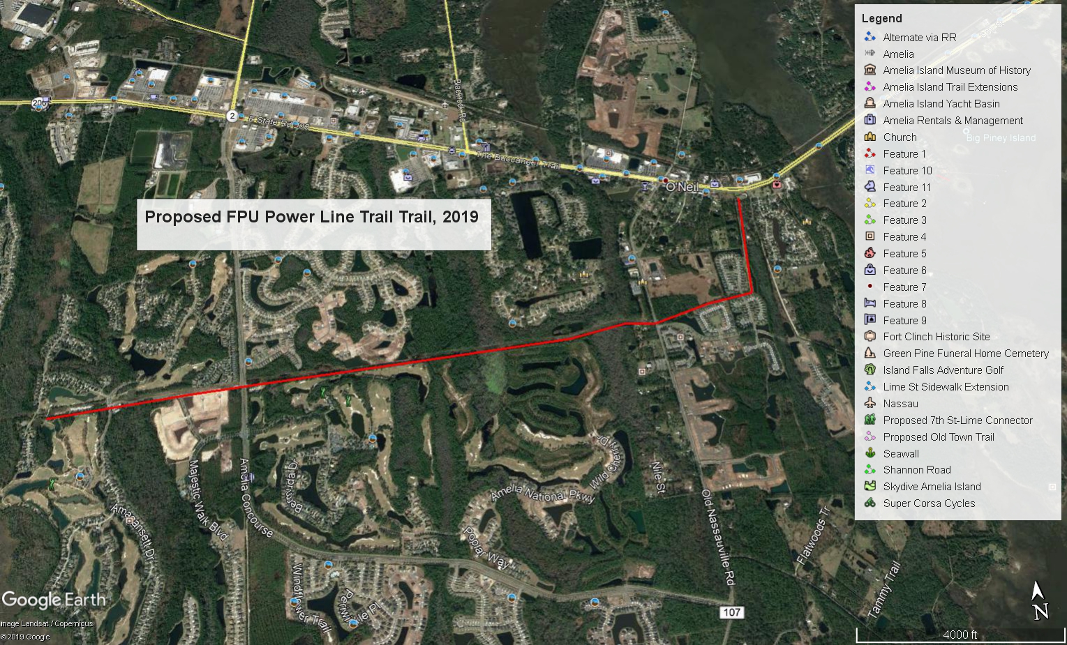
 Water Taxi service to St Marys, Geordia
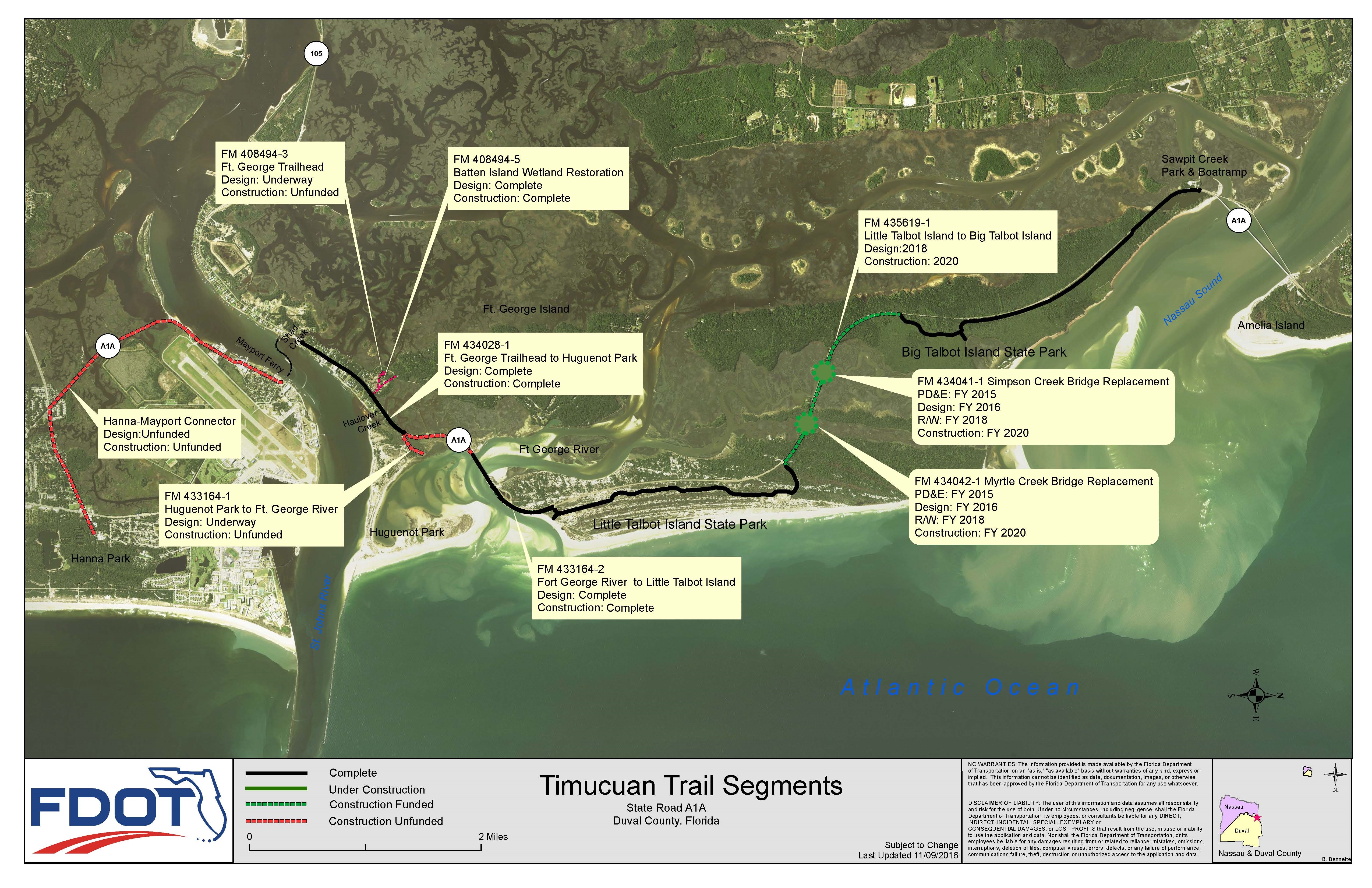 Timucuan Trail segments
 Heckscher trail project
 Heckscher bridges project
 Heckscher bridge project typical bridge